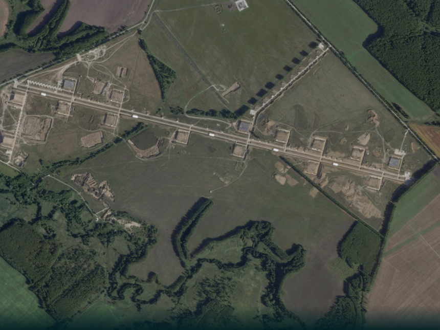
Recent satellite images showed the continuation of construction and expansion operations at a Russian military site near the village of Tsymbulova in the Oryol Province, western Russia, a site identified by previous intelligence reports as one of the bases for launching witness/neighbor marches used in attacks on Ukraine.
A visual comparison of the images reveals that the site did not include clear military installations in August 2024, as it appeared as an open green land, before gradually turning into a distributed facility that included internal roads, dirt berms, small shelters, and potential preparation and launching areas, with development work continuing until the latest images available this April.

From open ground to a marching base
The images show that the pace of development accelerated between August 2024 and February 2025, as the operational pattern of the site became clearer. Main roads have appeared extending inside the base, rectangular areas surrounded by dirt barriers, and small facilities distributed on both sides of the main axis, in addition to a network of internal paths that allow the movement of vehicles between potential storage, processing, and launching areas.

This visual analysis intersects with a report by the Molfar Intelligence Foundation, which said that it identified the site near Tsymbolova based on leaked documents as a base for launching Shahid/Jeeran marches, noting that the infrastructure of the site had been largely completed by February 2025.
Read also
list of 1 itemend of list
The most recent image available from Planet Labs PBC, dated April 22, 2026, shows continued development of the site, showing long linear paths and newly leveled areas, along with new facilities and berms compared to the 2025 images. This indicates that the base continued to add new operational infrastructure after most of its basic facilities were completed.

The structure is akin to running marches
The facility located near the village of Tsymbulova does not appear to be an air base in the traditional sense, as it does not include a clear runway for manned aircraft. According to reading the pictures, it appears closer to an operating facility for marches, based on long roads, small shelters, dirt berms, distributed preparation areas, and corridors that allow the movement of launch or support vehicles within the site.

This type makes the site more suitable for long-range drone operations compared to the traditional structure of military airports, especially if its use is linked to mobile launch pads or field equipment that do not require wide flight runways.
The base gains additional importance due to its location in the Oryol Province, western Russia, at a relatively close distance from the Ukrainian border, which places it within the range of rear sites that can be used to prepare and launch marches towards targets inside Ukraine, while remaining outside the direct confrontation line.
Thus, the chronology of images provides strong visual evidence that Russia developed this site from an open space since August 2024, then transformed it in less than two years into a specialized facility with a large structure for storing, preparing and launching marches.