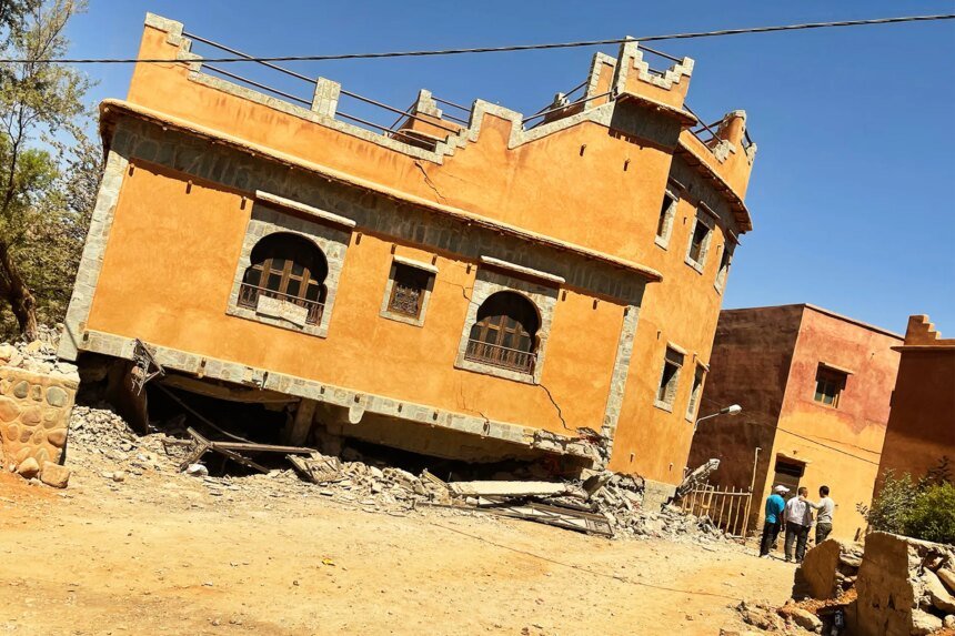
Nearly three years after the devastating Al Haouz earthquake that struck the High Atlas Mountains in Morocco on September 8, 2023, a Moroccan research team was able to uncover many of the secrets of this earthquake, which scientists described hours after its occurrence as “unprecedented,” without being able at the time to determine the details that made it appear that way.
Historically, this region records very slow tectonic movement (less than one millimeter per year), and it witnesses earthquakes that are usually of limited strength, and their source is the surface crust, but preliminary studies confirmed that the Al Haouz earthquake was deep and powerful, which then raised several questions about the precise fault responsible for the earthquake, how stress is transmitted to neighboring faults, and understanding the nature of the Earth’s crust and mantle in that region to know the main driver of this activity.
A study published in the journal Seismological Research Letters provided an answer to these questions, including details that overturned some scientific constants that had been studied in books for years and used in designing seismic hazard maps.

Superficial slowness does not always mean safety
One of the most prominent scientific constants is that which assesses the danger of any fault or mountainous area by measuring the movement of the Earth’s surface via GPS devices, and the prevailing trend is that areas with rapid tectonic movement (such as the San Andreas Fault in California or the faults of Japan) are the only ones that are worrying and generate major earthquakes.
This did not extend to the High Atlas Mountains, where the devices were recording very slow deformation movement (less than one millimeter per year), which made the traditional view of the region as having moderate to low seismic activity.
Dr. Hafid Wamo, from the Research and Development Laboratory in Applied Earth Sciences at Abdelmalek Saadi University in Morocco, and the corresponding researcher on the study, says to Al Jazeera Net: “We proved in our study that the slow rate of movement on the surface can be very deceptive. While the surface moved by less than one millimeter per year, there were blind and hidden faults in the deep depths that were trapped and accumulated stresses very slowly over hundreds or thousands of years without any signs appearing on the surface, until they suddenly exploded in a catastrophe.” Major, and therefore one of the important results we came up with was that “tectonic slowness does not mean safety, but rather it may mean a postponed earthquake with greater depth and greater strength.”
A new theory of rock behavior
Another common constant in geology is that the “upper crust” is cold and brittle, and its rocks suddenly break when exposed to pressure, like a car window, which is responsible for devastating earthquakes. As for the “lower crust,” because of the extreme depth and high temperature, its rocks become rubbery, behaving like warm putty, and therefore when exposed to tectonic pressure, they expand and deform slowly and continuously. Therefore, it was scientifically believed that it was unable to store the energy of a violent earthquake. And release it suddenly.
Hafeez explains that the Al Haouz earthquake also changed this constant by exploding at a deep depth (between 15 and 35 kilometers), and its peak energy and rock fractures reached a depth of 26 kilometers (in the heart of the lower crust).
He added: “This means that part of the lower crust under the High Atlas Mountains is mechanically strong and cold enough to behave brittle and frictionally to break like bones.”
The research team succeeded in explaining this rare behavior of rocks using three-dimensional seismic tomography of the Earth’s interior under the Atlas. The images showed that the earthquake epicenter area contains a very thick earth’s crust, ranging from 45 to 50 kilometers, which is the thickness that supports the weight of the tall mountains, and acts like an “insulator”, protecting the deep rocks and making them always cool and solid for a longer period.
At the same time, there is a hot heat flow coming from the depths that compresses and melts the Earth from below.
Hafeez says, “These two factors converged at one point (the lower crust). The cold coming from the thick crust at the top made the deep rocks refuse to melt and remain solid, while the thermal pressure coming from below with the pressure of the continents put them under terrible stress. When the pressure exceeded its limit, these deep rocks behaved completely opposite to their warm nature; instead of expanding like soft dough, they suddenly broke like dry bones, unleashing the force of the devastating Al Haouz earthquake.”
Hafid stresses that what they observed in the Al Haouz earthquake in Morocco does not mean that the entire lower crust under the High Atlas is capable of generating earthquakes everywhere.
He says: “The matter depends on very precise and local balances that differ from one place to another and include the type of minerals that make up the rock and their extent of tolerance, and the local temperature, as any slight change in temperature turns the rocks from brittle to plastic, and finally, the presence of fluids and the state of tectonic stress in that region.”

Satellites reveal the culprit
Since the fault responsible for the earthquake remained buried in the ground, the question was how scientists succeeded in tracing it.
Hafeez says, “By comparing the images provided by the space radar (INSAR) carried on the Sentinel 1A satellite, before and after the disaster, we detected a wide bulge and curvature of the Earth’s surface, where areas rose by 18 centimeters, and others retreated by about 15 centimetres.”
He explains that “these numbers were entered into super computer simulation programs that tested millions of possibilities for the shape of the crack in the depths, and the result was that the culprit was a ‘severe northward-slanting fault’, which slopes into the ground at a sharp angle of about 69.5 degrees, and extends horizontally in a direction that is completely in line with the natural structure of the High Atlas Mountains, lying below the famous ‘Tizi-Natast’ fault system.”
He added, “This model succeeded in explaining why the Earth swells on the surface in this way, and it completely matches the direction of the seismic waves monitored by ground stations.”
The door to ijtihad is still open
Despite the strength of this model, Hafeez admits that the controversy has not been 100 percent resolved, as there are studies by other researchers that suggest a different geometry, such as a fault inclined toward the south at a moderate angle.
Hafeez attributed this exciting dispute to the nature of the blind fault. When the fault refuses to emerge to the surface and remains buried at a depth of 26 kilometers, the signals and distortions that appear on the face of the Earth are very similar, making the distinction between “tendency toward the north” or “tendency toward the south” dependent on very precise mathematical and geophysical details.
He says: “We do not judge other opinions by error, but we are confident that our (north-leaning) model is the most coherent and consistent with all available data.”
4 pillars for investing in the results of the study
The final resolution of this point remains just a subsidiary issue that should not divert attention from the larger lesson learned from this study, which is the necessity of including “hidden blind faults” and deep earthquakes, which explode in the lower crust, as a basic and direct element in building risk maps and determining the thickness of walls and concrete in upcoming urban projects.
Hafeez says: “Ground movement monitoring devices (GPS) have always reassured experts that the Atlas Mountains are moving very slowly, not exceeding one millimeter per year, which has historically led to their classification as a region of moderate activity. But what we discovered in the Al Haouz earthquake proved that this slowness is nothing but a mask hiding behind it a silent and frightening accumulation of energy at unimaginable depths.”
In order to transform these discoveries into a real shield of protection for lives and facilities, Hafeez draws a clear road map for decision makers, requiring sustained investment in four main geophysical areas, which are the deployment of advanced and dense seismic monitoring stations to capture and locate deep earthquakes with great accuracy, permanent reliance on satellite technologies (INSAR) and GPS systems to monitor any deformation or very slow swelling in the surface that may indicate an upcoming danger, modernizing ground surveys to identify complex geological structures, and finally, Using advanced geophysical imaging techniques to capture clear 3D images of the deep Earth’s crust.