Published on 6/14/2026
|
Last update: 19:22 (Mecca time)
A digital investigative investigation by Al Jazeera reveals new data regarding Israeli military movements in the Gaza Strip, southern Lebanon and southern Syria, indicating that the declared “buffer zones” or military deployment lines hide a different field reality drawn by satellite images and geographical analyses.
The investigation, prepared by the digital investigations team at Al Jazeera Network and presented by journalist Hanan Al-Ayari, raises questions about the nature of these movements and the future of the region’s borders, based on geographic information systems techniques, data from the Armed Conflict Locations and Events Project, in addition to a temporal comparison of satellite images to monitor the changes that occurred after the ceasefire agreements.
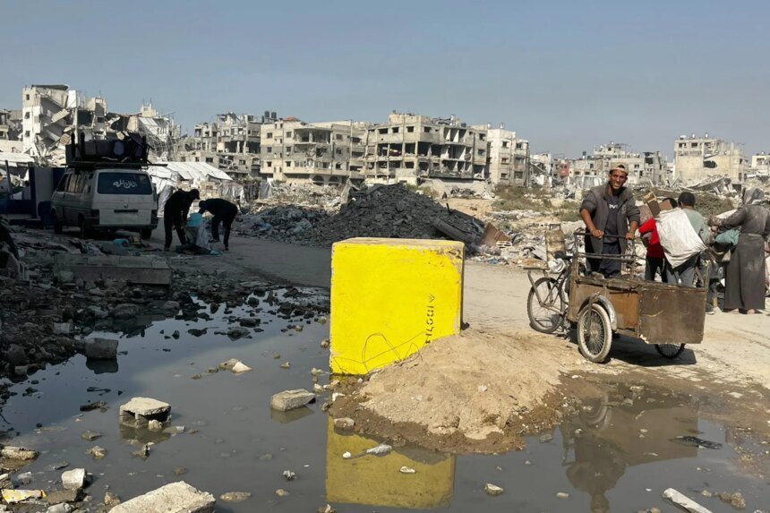
The investigation begins in the Gaza Strip, where Israel talks about the “yellow line” as a military buffer zone that prevents civilians from approaching it, while the announced maps indicate that it divides the strip into two areas. An eastern one under Israeli control, and a western one in which Palestinians are allowed relative freedom of movement.
However, the analysis of the Al Jazeera team, according to the investigation, showed a difference between the declared lines and what the satellite images reveal, as it turned out that the locations of the yellow cement markers placed by the Israeli army did not always adhere to the official declared borders, but rather exceeded them in several areas by hundreds of meters, especially in the northern Gaza Strip and Gaza City.
The investigation showed that the area of Israeli control in northern Gaza increased – according to the analysis – to tens of additional square kilometers, reaching approximately 55% of the area of the northern region, an increase estimated at about 5% compared to the areas that were under control before 2023, according to what the investigation concluded.
The indicators monitored by the investigation were not limited to the deployment lines, as the comparison between satellite images before and after the ceasefire showed, according to the investigation, demolition and destruction operations in areas that it said were located outside the declared borders, citing areas in the Al-Shujaiya neighborhood, east of Gaza City, in which extensive traces of destruction appeared.
Lebanese Front
The investigation moves to the Lebanese front, where it indicates that the pattern of Israeli movements was repeated in southern Lebanon, as the official maps spoke of specific deployment areas following the ceasefire agreements, but reviewing satellite images revealed, according to the investigation, movements outside the declared lines.
The investigation gave an example in the eastern town of Zawtar, noting that satellite images showed the destruction of a large number of buildings, in the context of what the investigation described as an expansion of the scope of military operations beyond the declared borders.

Military tape in Syria
As for Syria, the investigation shows that the picture is different due to the failure to officially announce a “yellow line” similar to what exists in Gaza and Lebanon, which prompted the team to study the Israeli military deployment by tracking the new military sites that appeared outside the “Alpha” line, which is the separation line between the occupied Golan and the rest of Syrian territory according to the 1974 Disengagement Agreement.
According to the investigation, analysis of Israeli military sites in southern Syria showed that they do not appear to be separate points, but rather an interconnected network that forms a military strip extending from Mount Hermon in the north to the Yarmouk River in the south. The investigation estimated the area of actual military control in that area at about 235 square kilometers.
The investigation also indicated that more than 800 Israeli incursions were documented outside the buffer zone into Syrian territory between December 2024 and January 2026, indicating that one of the deepest of these operations reached a distance of approximately 63 kilometers into Syrian territory near the Jubailiyah Forest in the Daraa countryside.
The investigation concludes that the total areas that were said to have come under Israeli military control after 2023 in the areas of Gaza, Lebanon, and southern Syria are estimated at about one thousand square kilometers, which is equivalent to an increase of approximately 5% compared to the areas that were under Israeli control before that.
The investigation puts these numbers in front of broader questions about the future of the region, and whether the temporary military lines will turn into new facts on the ground, in light of the continuing field changes that are redrawing the maps of influence and control on more than one front.