Published on 6/26/2026
|
Last update: 13:30 (Mecca time)
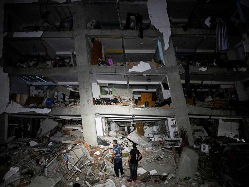
On the evening of Wednesday, June 24, 2026, Venezuela experienced one of its harshest recent seismic moments, when two powerful earthquakes struck the north of the country in less than one minute. The first had a magnitude of 7.2, and was followed just 39 seconds later by a stronger earthquake with a magnitude of 7.5.
The epicenter of the two tremors was near the northern coast, west of the capital, Caracas, and they were felt by residents of large areas, while the most severe damage was concentrated in cities such as La Guaira, Caracas, and nearby coastal cities.

Critical area
From a geological standpoint, northern Venezuela is not a static land. Rather, it is located at one of the active boundaries between tectonic plates, where the Caribbean plate is located to the north, and the South American plate is located to the south.
To understand this, imagine the Earth’s crust as huge slabs floating and moving above deeper, hotter layers of the Earth’s interior.
These plates are tectonic plates. They overlap like paper puzzle pieces, and their movement is very slow, often not exceeding a few centimeters per year, but they continue without stopping. When two plates meet, or one slides next to the other, areas of pressure and friction are formed, and faults arise, and these are the places that generate most earthquakes.
In the case of Venezuela, the Caribbean plate is moving eastward relative to the South American plate, which is a lateral movement, as if there were two huge rocky masses, each trying to slide along one another.
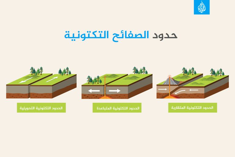
This type of boundary is called in geology a “transformation boundary,” and it results in lateral strike-slip faults, that is, faults in which rocks move horizontally on both sides of the fracture.
But this movement does not occur completely smoothly, as the two sides of the tectonic plate are not like two smooth glass plates that slide easily, but rather each of them consists of rough, interwoven rocks, full of zigzags.
Therefore, parts of the fault may be stuck for tens or hundreds of years, and over time, enormous energy accumulates in the rocks, just as energy accumulates in a compressed spring, and when this energy overcomes the force of friction, the balance is suddenly broken, the rocks slide, and seismic waves are released.
Spreading cracks
This is why earthquakes occur frequently in Venezuela, because the country lies on an active fault system, not on a completely stable continental mass. The most famous of these faults are the Pocono Fault, the San Sebastian Fault, and the El Pilar Fault.
The Pocono Fault extends in western Venezuela, is linked to the Venezuelan Andes, and is considered one of the most prominent active faults in the country. As for the San Sebastian Fault, it extends near the northern coast, in an area close to important population centers.
In the east, the El Pilar fault appears, which is also part of the complex tectonic movement network in the north of the country. These faults, and others, make northern, western and eastern Venezuela more vulnerable to seismic activity than more stable interior regions.
What makes matters more complicated is that the boundary between the two plates is not a simple straight line, but rather a wide area of deformation. That is, the movement is not entirely concentrated on one fault, but is distributed over several faults, branches, and small blocks.
Therefore, an earthquake may occur on a specific fault, and then some pressures are transferred to another nearby fault, thus increasing the probability of subsequent tremors or close earthquakes. From here we understand why earthquakes are not always a simple, single event, but rather they may come in series or in the form of successive tremors.

Strong earthquakes are rare
However, studies in this scope show that Venezuela is not one of the countries that witness large rates of “destructive earthquakes.” The reason for this is related to the nature of the relationship between the tectonic plates around the country, as they slide next to each other, and do not enter one below the other, as in the case of countries such as Japan or Chile.
Therefore, Venezuela’s major earthquakes are mostly in the 6 to 7.5 magnitude range, not the 9 magnitude range. However, when they are shallow and close to cities, they may cause widespread destruction, which is what happened in the case of the current double earthquake.
In a study published in the Sustainability journal in 2022 that relied on an earthquake database for the period between 1997 and 2021, researchers analyzed about 2,000 seismic events in and around Venezuela, whose magnitude ranged between 1.9 and 7.3 degrees.
With a simple calculation, this is equivalent to an average of approximately 80 seismic events per year within the study area, with a clear concentration of tremors near plate boundaries and active faults, especially in the Venezuelan Andes and the Trinidad and Tobago region.
At the national level, data from the Venezuelan Foundation for Earthquake Research indicate that the number of recorded tremors may reach several hundred per year.
According to the Foundation, about 371 earthquakes were recorded in 2016, then the number increased in 2017 to 456 seismic events.
Note that these numbers do not mean that the population feels all of these tremors, because most of them are small, but they reveal that Venezuela is located above an active seismic system and not on completely stable ground.
But the picture looks different when we look only at the earthquakes that caused damage, as the Foundation states that more than 130 earthquakes caused serious damage between the years 1530 and 2004, which means that the region witnesses many earthquakes, but they are mostly weak to moderate.