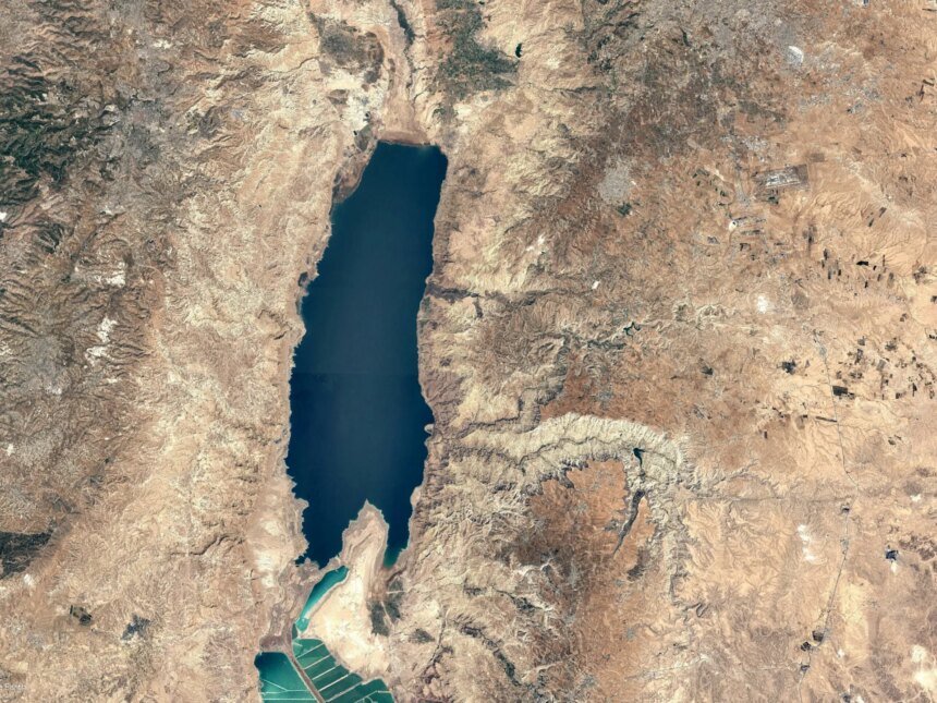
The Dead Sea is no longer fixed in place as visitors and resorts have known it for decades. The water line, which used to touch well-known tourist beaches, is receding year after year, leaving behind exposed salty land, areas that are difficult to cross to reach the water, and areas where the risks of potholes and collapses are increasing.
Satellite images analyzed by the Al Jazeera Network’s open source unit reveal that the decline is no longer a general environmental observation, but rather a clear visual shift that can be tracked from space. Between June 20, 2017 and June 15, 2026, the coastline moved away from the Dead Sea in several sections, and new areas of land appeared on its Jordanian and western sides.
The significance of the images does not stop at the borders of environmental change, but rather extends to the tourist front of the sea. The decline appeared clear in front of well-known beaches, resorts and visiting sites, which raises a direct question: How does the decline of the Dead Sea change the tourism map around the lowest point on the surface of the Earth?
A sea that turns away from its visitors
A comparison of Sentinel images taken in 2017 and 2026 shows a clear visual change in the coastline, with new areas of land that were previously under water exposed.
In the initial measurement conducted by the open source unit in the Al Jazeera Network, the retreat of the water line in some parts of the Ghor al-Mazraa district in Jordan reached about 2,400 metres, while the retreat on the western side reached about 1,450 meters near the historic Masada Castle.
What does the water indicator reveal?
Using the NDWI on Sentinel images, the difference between 2017 and 2026 appeared more pronounced in several coastal sections. This indicator is usually used to highlight the differences between bodies of water and land, which helps monitor the change of the shoreline over time.
The index images show that the decline extends over multiple sections of the sea.
Receding water line
Sentinel images show that a number of tourist beaches on the western bank of the Dead Sea were affected by the receding water line, including the beaches of Kalia, Neve Medbar, and Biankini Siesta, which are areas that include well-known tourist facilities and resorts.
According to the initial measurement, the distance of the water line in front of some of these sites ranged between about 43 and 97 meters at specific points, a difference that does not mean that these facilities stopped working, but it reveals that the tourist façade itself is moving in front of an unstable sea.
In Ein Gedi, one of the well-known tourist spots on the Dead Sea, the measurement showed that the beach had receded by about 45 to 88 meters at some points. The beach had been closed to the public for years due to the danger of sinkholes and the difficulty of accessing the water as the sea level dropped, according to what the Jerusalem Post newspaper reported in a report on the area.
Changing tourism
On the Jordanian side, images reveal that the receding sea also appeared in front of well-known coastal and tourist sites. On the southern salt and salt beaches, a wide strip of land that was previously submerged was exposed, while the retreat appeared smaller but also clear near the touristic Karak beach.
Within a range that includes prominent resorts such as the Marriott and Hilton Dead Sea, measurements show that the waterline moved away from parts of the coastal front by tens of meters during the period between 2017 and 2026, and the retreat at some points reached greater distances within the same range.
These numbers do not mean that resorts have completely lost touch with the sea, but they do reveal that the tourism sector operates on a rapidly changing coast, where access to water, beach management, and land hazard monitoring require plans to adapt to a new reality.
Hidden danger
As the water continues to recede, previously submerged salty lands are exposed. This is linked to the increased risk of sinkholes and landslides in some coastal areas, which are risks that may threaten roads, facilities, and tourist facilities, not just the beach.
The US Geological Survey explains that the decline in the water level of the Dead Sea helps the formation of collapse craters on the exposed sea floor and nearby coastal areas, making urban and tourist development in some locations more dangerous.
In a special report issued in 2025, the Israeli State Comptroller’s Office described the Dead Sea as an important natural, touristic and economic asset, noting that large areas of it dried up over the years, and that part of the exposed lands became linked to industrial uses and evaporation ponds.
Changes over decades
The decline of the Dead Sea does not appear to be a temporary seasonal change, but rather a decades-long path, and data from the US Geological Survey (USGS) and Landsat image series show that the sea has witnessed a clear decline over the past half century, with a noticeable change in the coastline and the expansion of exposed areas around the northern basin.
Monitoring of the Dead Sea conducted by the Israel Oceanographic & Limnological Research Institute, in cooperation with the Israeli Geological Survey, also indicates that the decline is linked to a decrease in flow reaching the sea, especially from the Jordan River, in addition to the use of its water in industrial activities.
Why is he backing down?
The decline of the Dead Sea is mainly related to the imbalance in its water balance. Less water enters it, while it continues to be lost through evaporation and industrial use.
The Dead Sea is a closed basin that does not have natural access to a sea or ocean, so any shortage of water entering it quickly appears in the form of a decrease in the level and a decline in the coastline.
The decline in flows coming from the Jordan River and its tributaries is one of the most important influential factors. With the expansion of irrigation projects and agricultural, domestic and industrial uses, the amounts of water reaching the sea decreased.
According to data from the US Geological Survey, the Dead Sea historically received much larger quantities of water coming from the Jordan River, before diversion projects and various uses significantly reduced the flow reaching it.
The hot and dry nature of the region exacerbates the problem. NASA states that on a hot, dry summer day, the sea surface may lose about 2 to 3 centimeters due to evaporation. But evaporation is not the only reason, as its effect becomes greater when the water entering the basin decreases.
Industry pressure
In the southern basin, companies from Israel and Jordan pump water from the Dead Sea into evaporation ponds to extract potash and salts, adding additional pressure to the water balance.
The US Geological Survey also indicates that the average annual rainfall around the Dead Sea is approximately 50 millimeters, which makes the impact of diverting water from the Jordan River and its tributaries greater than the impact of rain alone.
Satellite images reveal a clear visual aspect of the Dead Sea crisis, but they do not tell the whole story. The apparent decline on the coast is the result of an accumulation of water, climatic, and industrial factors that have spanned decades, and today it has turned into a direct challenge to tourism, infrastructure, and beach management, including tourist facilities operating on a declining coastline, beaches that need to be re-conditioned, and exposed lands that may carry the risk of holes and collapses.
The Dead Sea crisis appears as both a tourism and an environmental story; The story of a receding sea, resorts chasing the waterline, and an entire region searching for a way to live with a geography that changes year after year.