The classical theory of continental separation speaks of a mechanism much like a “clothes zipper”; The continent does not usually split at once along all of its borders. Rather, the rupture begins from a specific area in which the earth’s crust is weaker or more exposed to tension. Then this rupture extends gradually in one direction, just as clouds open from the starting point and then continue to open year after year.
According to this perception, the process begins when the continental crust is exposed to enormous tensile forces resulting from the movement of tectonic plates in the interior of the Earth. As tension continues, deep cracks and faults appear in the crust, and these cracks expand very slowly over millions of years.
After that, magma may rise from the Earth’s mantle into the rifted areas, fill the resulting voids and cool, forming new oceanic crust. Thus, the continental rift gradually turns into a small marine basin, and then into an emerging ocean that separates two continental masses that were originally connected.
The “clothes zipper” metaphor is useful because it explains the gradual and directed nature of separation. Instead of imagining the two continents suddenly moving apart as two separate pieces, one should imagine a long line of geological weakness beginning to open at one end, along which the separation proceeds step by step.
One of the most famous examples needed to illustrate this idea is the separation of South America from Africa when the South Atlantic Ocean was formed. The separation did not occur entirely at one moment, but rather began in certain areas and then gradually extended along the two continental margins, leaving behind a striking similarity in the shape of the coasts, and similarity in the rocks and fossils on both sides of the ocean, as if the two continents were two pieces of one cloth and an enormous geological cloud had opened between them.
Christian Rowan, of Columbia University’s Department of Earth and Environmental Sciences, recently discovered that this is not the whole story: Africa is currently being torn down the middle at a quiet rate.
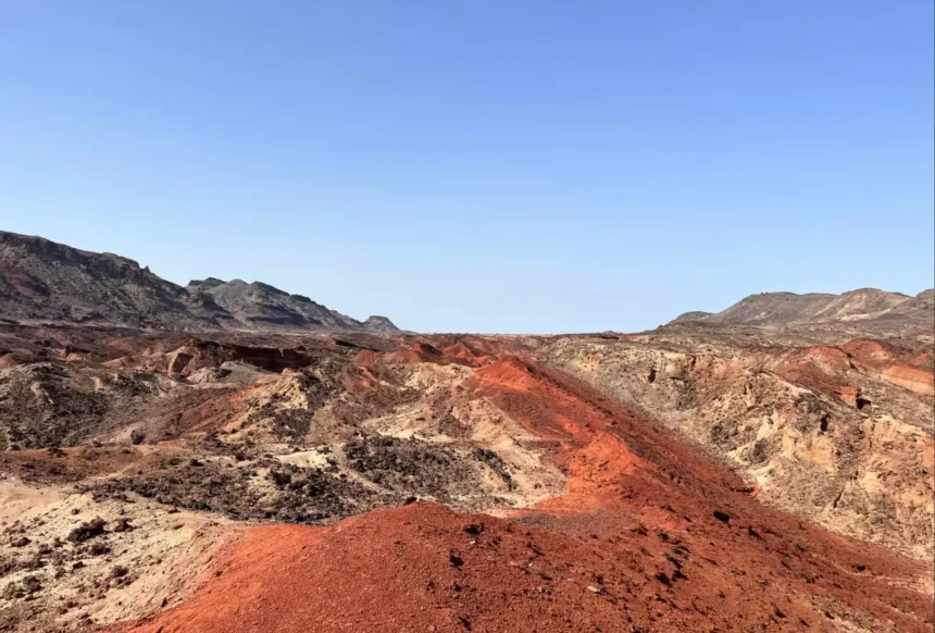
Rawan says in statements to Al Jazeera Net: “According to the traditional concept, it was expected that the separation in Africa would begin from the “Afar Fault” in Ethiopia in the north and then gradually extend towards the south, but what happened is that the deep tensile forces focused their blows in the heart of the “Turkana Fault” between Kenya and Ethiopia, causing thinning in the earth’s crust until its thickness eroded to only 13 kilometers. This critical stage puts East Africa on the path of inevitable separation, and shatters the traditional models of how the continents separate and are born. oceans.”

“A piece of gum” explains the story
To understand what is happening, if you try holding a piece of gum and pulling it with your fingers from both ends, you will notice that it begins to elongate, and becomes very thin in the middle before it breaks.
Likewise, this is what is currently happening slowly underground in the East African region, which includes Kenya, Ethiopia, Somalia, Mozambique, and parts of Tanzania, through a process known as “realization.”
Waxing is a sharp and accelerated local thinning that affects the Earth’s crust and lithosphere as a result of tensile forces resulting from plate divergence, and it is the critical point that paves the way for separation.
This point is preceded by two stages. The first is “distributed expansion,” where deep tectonic tension forces begin to pull the plates, but the Earth is strong and flexible enough to withstand this initial pressure without permanent deformation, just as you begin to pull a piece of gum very gently at first, and it expands with you for a distance of a few millimeters, and if you leave it at this moment, it will shrink and return to its completely original size and shape.
As for the second stage, which is “concentration of stress,” as the separation continues, the lithosphere is unable to bear the tension in a distributed manner, so the deepest and hottest layers (the mantle) relax, and all the mechanical effort is transferred to focus on one narrow point (the axis), which also happens in application to the same example. If the tension continues with greater force between the two ends of a piece of gum, it will exceed the limit of elasticity, so that if you leave it it will not return to its original shape, and you will notice that it elongates and its thickness decreases gradually and equally along the entire length of the piece.
As the pulling continues, the stage of “waisting” is reached, where the solid crystalline crust in the center of the crack thins very quickly compared to the edges, and magma rises from the mantle to fill the void from below, which is what happens in a piece of gum when you continue to pull between its two ends, reaching a point where you are unable to distribute the effort, and choose the “weakest point” in the middle, and all the pulling and deformation energy is concentrated there, and you suddenly notice that this particular point has become very thin, like the “neck,” while The ends of the gum closest to your hands remain as thick as they are.

The new study by researchers from the Department of Earth and Environmental Sciences at Columbia University monitored this process in the “Turkana” fault between the Nubian plate and the Somali plate, where the former represents the basic and largest block of the current African continent, and is located on the western side of the fault (it includes countries such as Egypt, Sudan, Libya, and most of central and southern Africa).
While the Somali plate, which is the smaller plate, is located on the eastern side, and includes the Horn of Africa region and the eastern coastal strip of the continent, including Somalia, Kenya, Ethiopia, and parts of Tanzania and Mozambique.
The Somali plate moves away towards the east towards the Indian Ocean, while the Nubian plate moves slowly towards the west and north, and the common line of contact between them is what forms the “East African Rift System”, specifically the “Turkana” fault zone, which is experiencing the critical stage of “waisting” and thinning under the influence of this mutual pull.
Using high-resolution seismic data, scientists found that the solid crystalline crust of the Earth under the axis of the Turkana fault had unexpectedly eroded and thinned until its thickness reached only 13 kilometers, while in areas far from the center of the fault, the thickness of the Earth’s crust exceeds 35 kilometers, which means that the crust has lost more than half its thickness in the fault zone.
The “fastest” and most critical stage
Returning to the example of the “piece of gum”, the 13 kilometers is the “skinny neck” that you see in the middle when you continue to tighten both ends of the piece, and it took millions of years to reach this stage.
According to the timeline presented in the study, tectonic tension forces began tearing this region of East Africa apart for the first time about 45 million years ago, and continued for approximately 5 million years. At that time, the Earth’s crust was still thick and strong (more than 35 km), and the expansion was very slow and distributed over a wide area.
Then, over the course of 40 million years, the tightening continued very slowly, and the thickness of the crust decreased from 35 km to about 20-25 km, and the continent was then going through a phase of “uniform stretching”, in which there was not a single weak spot, but rather the entire region was slowly thinning.
Only about 4 to 5 million years ago, the stage of violent tension began that brought the crust to the critical limit (13 km), which Christian likens to what happens in “materials engineering.”
He says: “The thinner the solid Earth’s crust becomes, the more it loses its ability to resist mechanically to tensile forces. This sharp thinning (up to 13 km) makes it very easy for the cracking forces to continue and accelerate, as the effort required to tear apart the remaining rocks decreases, paving the way for final separation.”
According to the study, we needed 40 million years of slow tension to thin the crust in general, and we only needed the last 4 to 5 million years to reach the severe thinning (13 kilometers). This was helped by a series of huge volcanic eruptions that weakened the structure of the Earth’s crust and facilitated its expansion.
This means that the geological process has accelerated about 10 times in the last 5 million years, compared to before, which proves that Africa is now in the “fastest” and most critical stage in the history of its separation.
When does the “skinny neck” break off?
Rawan and his companions determined the current rate of separation at “4.7 mm per year,” and this rate was monitored in real time via Global Positioning System and satellite stations (GPS – GNSS), installed on both sides of the rift (the Nubian plate and the Somali plate).
Although this rate seems small (less than the rate of growth of human nails), it is not so on the geological time scale, as Christian confirms.
He says: “According to the current human perspective, the African continent is still cohesive and geographically intact today, and there is no danger of a sudden land separation that man sees in his daily life, but according to the geological perspective, which looks millions of years ahead, regions such as Kenya and East Africa have already and definitely entered the early stage of a long-term separation process. The land there is in a state of continuous deformation and expansion, and the distant inevitable scenario is the emergence of a completely new ocean basin that separates this region from the main body of the continent.”
According to the rate of “4.7 mm per year”, in 100 years the two plates will diverge by 47 centimeters (about half a meter), and in 10 thousand years the continent will diverge by 47 metres, and the distance will expand in a million years by 4.7 kilometers.
As the tension continues, simple annual horizontal divergence will be enough to completely end the rocky bond within a few million years, separating the eastern African continent, and moving to the stage of ocean formation, where the waters of the Indian Ocean will flow to fill the void and create a new sea or ocean that separates eastern Africa from the rest of the continent.