On June 24, as Venezuela was entering the early evening hours, the north of the country was shaken by two successive major earthquakes less than a minute apart. The first had a magnitude of 7.2, and the second – which was the strongest – had a magnitude of 7.5, near the Yumari area, west of the capital, Caracas, making it the strongest strike perhaps since the beginning of the last century.
Scientifically, what happened is closer to what seismologists call a “double earthquake,” which is a term that expresses an event during which two large earthquakes occur close in space and time, such that the second is not just a “small aftershock,” but rather a strong, independent or semi-independent earthquake on another part of the fault or on an adjacent fault.
A fault is a large fracture or fissure in the rocks of the Earth’s crust, along which rock masses move. When it suddenly slides after pressure builds up on its sides, an earthquake occurs.
This means that the first earthquake changed the distribution of stress (energy) in the Earth’s crust, bringing it closer to an area that was already about to break, and it moved shortly afterward.
Therefore, the matter is more dangerous than a single earthquake, because the buildings that were weakened by the first earthquake receive a strong second blow. Among the most famous recent examples are the earthquakes in Turkey and Syria on February 6, 2023, where there was a first earthquake with a magnitude of 7.8, then about 9 hours later another earthquake with a magnitude of 7.5 occurred on a nearby fault system.
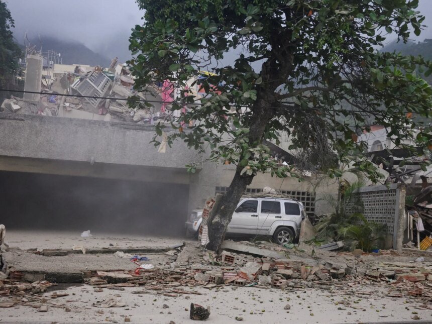
Therefore, the first numbers were heavy in the case of Venezuela, where many buildings collapsed inside Caracas and services stopped, and the death toll from the two earthquakes rose to at least 32 dead and more than 700 injured.

What does a 7.5 magnitude earthquake mean?
When we say that an earthquake has a magnitude of 7.5, we are not talking about a “slightly stronger shaking” than a 6.5 earthquake. The scale of the magnitude of an earthquake is logarithmic, meaning that every full degree means a huge increase in the energy released.
In this context, an earthquake with a magnitude of 7 releases approximately 32 times more energy than an earthquake with a magnitude of 6, and about a thousand times more than an earthquake with a magnitude of 5. The difference between 7.2 and 7.5, although it seems small in number, means that the second earthquake released approximately three times more energy than the first.
But “strength” is not everything. There is an important difference between the magnitude of an earthquake and the intensity of the shaking that people feel. The amount is one number for the entire event, but the intensity varies from one city to another, depending on the proximity to the center, the depth of the focus, the type of soil, and the nature of the buildings. Therefore, a medium, nearby, shallow earthquake may be more destructive in a given city than a larger, but deep, or distant earthquake.
In the case of Venezuela, the main problem was that the largest quake was shallow, at a depth of only about 10 kilometers. Shallow earthquakes are usually more dangerous, because the energy does not dissipate as much before it reaches the surface.
That is why preliminary assessment maps showed that cities such as Puerto Cabello and San Felipe were exposed to high shaking intensity, while the tremors reached wider areas of the north of the country, including Caracas.
Why did the earthquake happen?
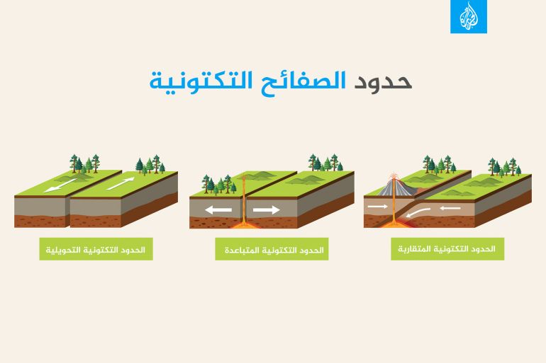
Northern Venezuela is located on an active tectonic border between the Caribbean Plate and the South American Plate. Tectonic plates are massive plates of the Earth’s crust that move slowly over a plastic layer in the Earth’s interior, and at their borders mountains, earthquakes, and volcanoes arise.
These two plates do not simply collide, as happens in famous subduction zones such as Japan or Chile, but rather move in a complex lateral movement, with some amount of pressure and compression.
To understand the idea, imagine that we are dragging two huge adjacent pieces of concrete, in opposite directions, and they rub against each other during movement, and a bump here may attach to another here, then this attachment is loosened and the two pieces move suddenly. This is what happened in the case of the Venezuela earthquake, where two neighboring tectonic plates moved, but the sliding is not smooth, as the edges are jagged, clinging to each other for years or decades, and then they suddenly break away.
In Venezuela, there is a system of active faults or faults, most notably Pocono, San Sebastian, and El Pilar. These faults represent part of the boundary between the Caribbean and South American plates, and they are capable of producing strong earthquakes, especially when a relatively long piece of the fault moves or when the fracture moves from one part to another in a short time.

Why was the impact so severe?
The seismic disaster is not caused by the earth alone, but rather by the earth when it meets the city.
There are three basic factors that explain the danger. The first is the shallowness of the earthquake, as we mentioned above. The second is the proximity of densely populated areas to the range of strong shaking. The third is the fragility of some buildings. Buildings that are not well-reinforced, or built with unreinforced bricks, or that were not designed according to strict seismic codes, are more susceptible to cracking and collapse.
In relatively remote cities, such as Caracas, soil may play an additional role. Cities located on sedimentary basins or soft layers may witness amplification of seismic waves, meaning that the soil itself makes the shaking longer or stronger than expected compared to solid rock. Therefore, distance alone is not a guarantee of safety.

Is Venezuela a major earthquake zone?
The common impression is that Venezuela is not like Japan or Chile in terms of earthquakes, and this is partly true because the country is not located on one of the famous giant subduction belts that produce magnitude 8 and 9 earthquakes. Subduction zones are places where one tectonic plate sinks under another plate into the Earth’s interior, often resulting in strong earthquakes, volcanoes and mountain ranges.
However, despite this, Venezuela is not far from seismic danger, as northern Venezuela is a truly active region, and the country’s history includes devastating earthquakes, including the Caracas earthquake in 1812, the Caracas earthquake in 1967, and other earthquakes in the twentieth century and the beginning of the twenty-first century.
The difference is that large earthquakes there are less frequent than in major subduction zones, and long decades may pass between one major event and another. These long time intervals deceive public memory; The city forgets, the population changes, the old buildings remain, and then the crack suddenly returns to remind everyone that calm is not evidence of the absence of danger.
There is also a geological reason: North Venezuela’s faults are mostly complex, lateral strike-slip faults, rather than giant subduction zones extending hundreds of kilometers under the sea like in Chile or Sumatra.
Therefore, its major earthquakes are mostly in the range of 6 to 7.5, not in the range of 9. However, when they are shallow and close to cities, they can be very destructive, which is what happened in the case of the current double earthquake.

Are there tsunami risks?
The earthquake occurred near the coast and was large and shallow, so it is natural for warning centers to check the possibility of a tsunami.
But lateral strike-slip earthquakes, where blocks mostly move horizontally, are less efficient at pushing the water column vertically than subduction earthquakes, which suddenly raise or lower the seafloor, so an initial precautionary warning was issued, then canceled when measurements showed the risk to be limited or uncertain.
This does not mean that the warning was wrong, but rather it means that the warning system operates according to the principle of caution, and then updates its assessment as better data arrives from monitoring devices and sea level measuring stations.
What will happen next?
Scientists expect the start of a series of aftershocks, all of which will likely be less intense than the two main earthquakes in intensity and strength. Despite this, the first hours and days will be very dangerous, not only because of the search for survivors, but also because of the possibility of the collapse of structures that have cracked and have not yet fallen.
Scientifically, it is not possible to precisely determine the date of the next aftershock nor its strength, but it can be expected that the number of aftershocks will generally decrease with time. At the response level, the priority becomes evacuating damaged buildings, inspecting bridges, hospitals, airports, gas and electricity networks, and providing clear information to the population so that rumors do not fill the void.