Published on 6/20/2026
The ongoing Israeli attacks on southern Lebanon were not just a series of military operations linked to temporary field objectives, but rather created a new reality on the ground whose repercussions seem to continue even after the fighting stops. Behind the bombing and destruction, a border strip emerged that Israel is trying to establish as a fait accompli, in an area extending from opposite Naqoura in the west to Shebaa in the east, and which it describes as the “advanced defense line” or “yellow line.”
This strip extends between 7 and 10 kilometers deep into Lebanese territory, and includes about 55 towns and villages, in addition to two major cities in the south, Khiam and Bint Jbeil, on an area estimated at approximately 600 square kilometers.
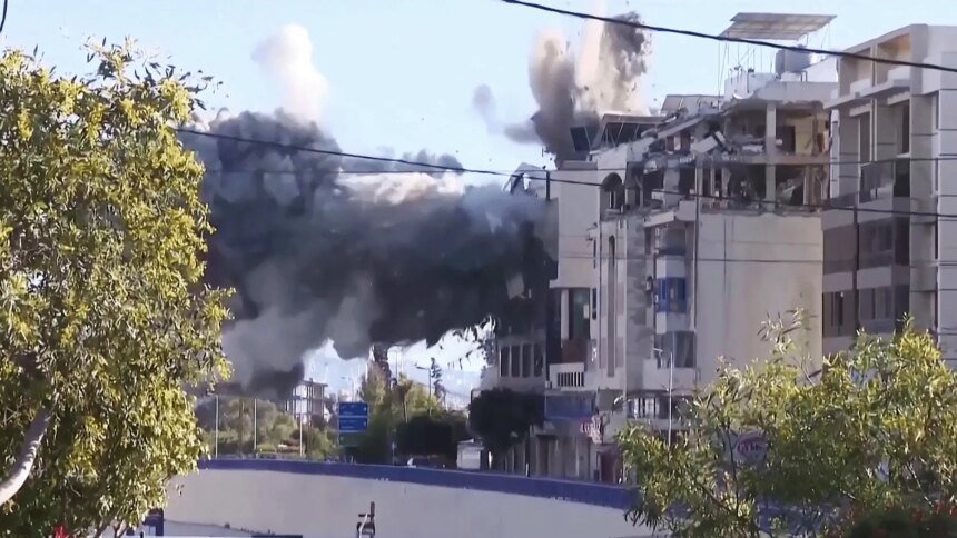
But the importance of this region is not only related to its geographical location, but also to the large-scale destruction it has been subjected to, which has changed its urban and demographic features.
In a number of border villages, the Israeli strikes did not just leave repairable damage, but rather led to the erasure of entire parts of the urban landscape, as villages almost disappeared from the map, while dozens of other villages were subjected to major destruction.
Lebanese believe that this destruction is not limited to the military aspect, but rather carries repercussions related to the attempt to change the identity of the place and create a new border region that is less clear and more interchangeable.
The destruction did not stop at the direct border line, but rather extended to wider areas south of the Litani River, to include at least 57 towns and villages. Before the war, this region included more than half a million people, making the extent of the damage go beyond buildings and facilities to change the form of daily life for its residents.
The final figures for the extent of losses are still unclear, as assessing the number of homes that were completely or partially destroyed requires extensive surveys after the end of military operations and the withdrawal of Israeli forces from the areas they entered or were deployed in. The reality left by the war represents a new urban map that requires a long time to determine its true size.
The Israeli strikes also affected civilian infrastructure in southern Lebanon, where 17 health facilities, including hospitals and medical centers, were damaged or put out of service, including the three main hospitals in the city of Tyre: Jabal Amel Hospital, Hiram Hospital, and the Lebanese-Italian Hospital.
The losses were not limited to facilities, as about 135 health and emergency sector workers were killed and nearly 400 others were injured during military operations.
Challenges of operating basic services
The impact of the war extended to schools, municipalities, government institutions, and water, electricity, and communications networks, making restarting basic services a major challenge for regions that began preparing for the post-war phase.
Even roads and bridges were not spared the effects of the confrontations, as the southern transportation network was subjected to direct strikes that led to the destruction of a number of vital bridges, including the Al-Qasimiya Bridge on the coastal road, the Al-Qasimiya Sea Bridge, and the Al-Dalafa Bridge, in addition to six other bridges and subsidiary ferries, which caused the isolation of some villages and complicated movement of movement between the southern regions.
But the most sensitive aspect relates to the population map that changed due to the war. More than 1.2 million people were forced to leave their homes during the various stages of fighting, in one of the largest waves of displacement that Lebanon has witnessed in its modern history.
Before the war, the area south of the Litani River included between 250,000 and 350,000 people, while the adjacent areas south of the Zahrani River included between 300,000 and 400,000 people, according to unofficial estimates.
The debate in Lebanon is no longer related only to the number of victims and the size of material losses, but rather revolves around the nature of the reality left by the war. Israel does not spread across all the towns of the so-called “yellow line,” but it maintains a military presence in parts of it, while a large section of the border area has practically turned into a de facto contact area or buffer zone, which has changed the nature of the southern border from what it was before the war.
On the legal level, the scale of destruction and displacement raises questions related to international humanitarian law, as the rules of international law indicate that the large-scale destruction of civilian property without military necessity, or the targeting of civilian objects, may fall within acts that can be considered as grave violations if the necessary legal conditions are met to prove them before the competent judicial authorities.
The issue of population displacement also raises a legal debate, as the Rome Statute of the International Criminal Court considers that the forced transfer of population as part of a widespread or systematic attack against civilians may fall within crimes against humanity.