In a field development that raises fundamental questions about the future of the fragile ceasefire in southern Lebanon, analysis of satellite images and geographical and field data reveals that the Israeli army is continuing to consolidate what has become known as the “yellow line” within Lebanese territory.
These moves reflect an Israeli effort to impose a new security and geographical reality that goes beyond previous UN arrangements, by establishing a buffer belt extending between 1.2 and 12 kilometers deep north of the internationally recognized Blue Line, which practically means separating dozens of border villages and towns from their surroundings, and turning them into restricted or prohibited areas that prevent their residents from returning to them.

According to the analysis, the “yellow line” does not appear to be just a temporary military measure, but rather part of a broader field engineering to reshape the border geography in southern Lebanon, through the systematic destruction of urban blocs, the opening of military corridors, and the expansion of areas devoid of population, in a manner similar to a process of “geographic amputation” that separates the south of the border from its population and natural extension.

A wide geographical scope that isolates dozens of towns
This line appears as a wide geographical belt that crosses a large part of the southern border, and includes a path that passes through about 85 towns and regions distributed over several districts, including 19 towns in the Tyre district, 23 towns in Bint Jbeil, 25 in Marjayoun, 11 in Hasbaya, 6 in Nabatieh, and a town in Rashaya.
Read also
list of 2 itemsend of list
This area extends to touch towns, most notably Iskenderun, Shama, Tair Harfa, Majdal Zoun, Aziyah, Zibqin, Beit Lev, Aita al-Shaab, Khiam, Shebaa, Kafr Shuba, and other villages that are now suffering under the threat of being targeted and prevented from returning. The area of this created buffer zone is estimated at approximately 568 square kilometers.

Deir Saryan and Warshaf…a comprehensive survey and leveling of the land
In Deir Saryan, a comparison between images from February 21 and April 18 showed the leveling of homes, the destruction of the local government building and the town mosque, in addition to the bulldozing of main roads and agricultural fields.
Deir Siryan is located about six kilometers from the Lebanese-Israeli border, and over the past weeks it has witnessed Israeli incursions, after a series of clashes with Hezbollah fighters.

In “Rashaf”, photos from April 16 revealed a huge destructive gap that included the destruction of entire residential areas, and the targeting of infrastructure and agricultural areas, which radically changed the town’s features.
Al-Qawzah and Beit Lev… targeting places of worship and vital facilities
The scorched earth policy extended to historical and civil monuments. In “Al-Qozah” and “Beit Lev”, photos from April 16, 2026 showed severe destruction to the Church of St. Joseph, built in 1927, in addition to damage to a site belonging to the United Nations Interim Force in Lebanon (UNIFIL).
Last March, UNIFIL announced that three peacekeepers were injured inside their base amid violent gunfire in the town of Al-Qawzah in southwestern Lebanon, noting that a fire that broke out at the base had been extinguished.
Despite the ceasefire agreement entering into force, the National News Agency reported on Thursday, April 23, 2026, that “Israeli forces carried out a major bombing in the town of Beit Lev in the Bint Jbeil district, the repercussions of which reached as far as the city of Tire and its towns.”
Aita al-Shaab… targeting schools, mosques and graves
In Aita al-Shaab, comparisons between the images of February 21 and April 16, 2026 showed violent destruction that included the complete sweep of a large number of homes, and the targeting of public mosques, the Aita al-Shaab Secondary School, and the municipal building, as well as the main cemetery, gas stations, and the roads linking to Naqoura.
The pictures also reveal that the main roads in the town were affected, including the Aita al-Shaab Road and the Naqoura-Rmeish Road, reflecting the expansion of the scope of destruction to include the internal traffic network and the town’s surroundings.

Majdal Zoun and Naqoura… Destruction affecting UN headquarters
The damage in the western sector was no less severe, as high-resolution images from Majdal Zone documented violent destruction concentrated in the eastern neighborhoods and around the roads leading to Tair Harfa.
According to visual comparison and image analysis between reference images dating back to February 24 and images from April 16, large parts of the town appear to have been subjected to violent destruction, ranging from complete obliteration to severe destruction of a large number of homes and residential buildings.

In Naqoura, which carries extremely important international symbolism, large parts of the town were razed to the ground, with more than 100 buildings completely destroyed, while other buildings were severely damaged in various parts of the town, and the damage extended to the fishermen’s port, which prompted Lebanon to submit an official complaint to the International Maritime Organization.
The pictures also show traces of damage to UNIFIL headquarters, reflecting the targeting of a very sensitive area.

Bint Jbeil and Khiam… the erasure of entire residential neighborhoods
As for Bint Jbeil, the destructive scene was disastrous. In the city, buildings and facilities were damaged and leveled between February 20 and April 14, 2026. The bombing included the Abdul Latif Saad School and the Ahl al-Bayt Complex, in addition to the Imam Hussein Mosque, the town’s government office, and damage to Bint Jbeil Stadium, a cemetery that showed signs of bombing, and the Bint Jbeil Ring Road.

In the town of Khiam, which has witnessed more than 25 air strikes and intense ground operations since late February 2026, entire residential neighborhoods have disappeared and inhabited areas have turned into urban voids, with the complete destruction of the historic Khiam Detention Center, the Imam Khomeini Complex, the town’s stadium and the Khiam Public School.

Double and nostalgic…destruction around the buffer zone
In the neighboring towns of Dibal and Hanin in southern Lebanon, satellite images taken on April 16 showed direct destruction targeting a number of homes.
The images also showed a more extensive level of destruction in Hanin, as large parts of the town appear to have been subjected to severe damage, reaching in some locations the leveling of entire buildings to the ground. The damage also affected the infrastructure, as the town’s roads were affected as a result of the rubble and the collapse of the surrounding buildings.

Continuation of the logistical isolation strategy
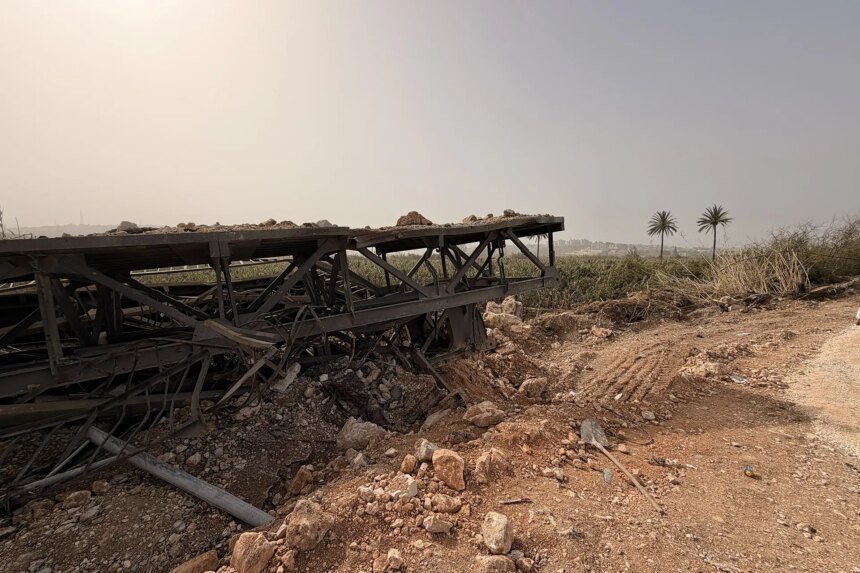
The imposition of this security belt and the destruction of the border villages comes as a continuation of the strategy of isolating southern Lebanon, which began by striking the logistical infrastructure, as satellite images taken on April 25, 2026 revealed the destruction of four vital bridges over the Litani River (Al-Dalafa Bridge, Al-Qasimiya Bridge, Al-Qantara Bridge, and the Zararia-Tirfalsih Bridge).
This confirms the interconnection between the destruction of bridges and the erasure of border villages in an effort to completely cut off the region and isolate it from its national depth.

“Yellow Line” tactics and official threatening statements
The “yellow line” is an internal military term in the Israeli army, and it extends in its current form from the Hasbaya District to pass the bend of the Litani River and ends west in Alexandretta.
In an official confirmation, on April 18, 2026, Israeli Army Chief of Staff Eyal Zamir vowed to target any potential threat, “including beyond the Yellow Line and north of the Litani,” coinciding with statements by Prime Minister Benjamin Netanyahu in which he confirmed the continuation of military action.
On the other hand, this path faces Lebanese rejection, as MP Hassan Fadlallah confirmed that the resistance will work to bring down this line, while military experts see it as an attempt to impose a “free-fire zone.”
These visual data reveal that Israel seeks, through the “yellow line,” to turn dozens of Lebanese villages into buffer zones and prevent people from returning to their homes.