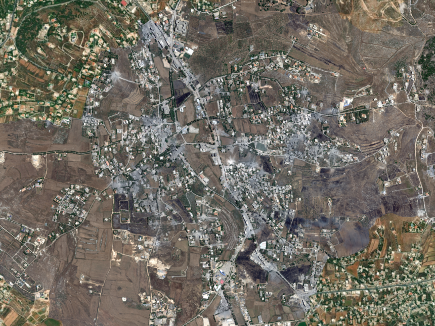
The town of Nabatieh Al-Fawqa in southern Lebanon was not as it appeared in satellite images taken on June 20, 2026, a few months ago. The scene monitored by satellites reveals a town whose features changed under the impact of Israeli air strikes: its buildings turned into rubble, while its roads were covered with traces of destruction, and green spaces appeared devoured by fire.
The importance of these images increases because they do not monitor Nabatieh Al-Fawqa alone, but rather extend to the vicinity of Ali Al-Taher Hill, one of the high and ruling points in the Nabatieh district, where traces of targeting and clear changes in the shape of the land and surrounding facilities appeared.
Read also
list of 2 itemsend of list
The Al Jazeera Network’s open sources unit compared recent satellite images taken on June 20, 2026, with previous images dating back to February 28 of the same year, to monitor the extent of the transformation in the town and the surrounding area of the hill, coinciding with the continuation of Israeli strikes and attempts to advance in areas close to the Litani River.
The comparison reveals that the damage was not limited to declared military points or a limited area of engagement, but rather affected buildings inside the town, prominent facilities, and a road network, while recent images documented fires and rising smoke at the time of the satellite’s passage, indicating that some traces of bombing or ignition were still relatively recent at the time of filming.
Before and after
The pictures show a wide difference between the scene in February and the scene in June. In Nabatieh above, dozens of buildings appeared to have been leveled or subjected to severe damage, and traces of rubble extended to parts of the road network inside the town.
As for the vicinity of Ali Al-Taher Hill, the images showed traces of destruction in specific buildings and points, in addition to clear changes in the shape of the land compared to the previous images.
Extensive fires and smoke
One of the most prominent features that appeared in recent photographs is the effects of widespread fires in Nabatieh Al-Fawqa and its surroundings. Areas of green areas appeared to have been affected by the fire, and the pictures – at the moment they were taken – documented the burning of several sites and the rise of columns of smoke from various points.
These visual indicators indicate that some fires or targeting effects were still ongoing or relatively recent at the time of the satellite’s passage.
Destruction of prominent buildings and facilities
Among the sites that showed signs of destruction or targeting in the photos were the Nabatieh Al-Fawqa municipality building and the large Nabatieh sports stadium, in addition to a gathering containing a large number of cars.
The images also showed that multiple residential buildings within the town were damaged, and rubble accumulated around some of them, affecting parts of the internal roads and movement of access to some areas.
Over the past weeks, the Lebanese National News Agency and local media recorded repeated Israeli raids on the outskirts of Nabatieh al-Fawqa and neighboring areas, including Kafr Tibnit.
Israel says that some of these strikes targeted Hezbollah sites, but satellite images and field monitoring also show traces of destruction in buildings, civilian facilities, and road structures within the affected areas.
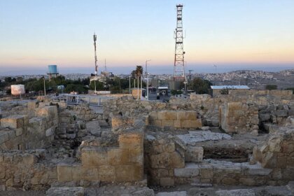
Ruling hill
Ali Al-Taher Hill is one of the heights of military and geographical importance in southern Lebanon, as it overlooks parts of Nabatieh District and roads linking the towns of the region.
In recent days, the hill and its surroundings have witnessed clashes and attempts to advance on the ground, at a time when local sources spoke of attacks carried out by Hezbollah using drones and anti-tank weapons around the area.
It is clearly visible that an underground facility was bombed as part of the attacks on Ali Al-Taher Hill. The Israeli “Alma” Center had said that Ali Al-Taher Hill, located north of Tibnin and about 4.5 kilometers northwest of Beaufort Castle, contains a tunnel structure that it described as strategic for Hezbollah. It is believed that it includes a headquarters for the Badr Unit and underground complexes, the largest of which is more than a kilometer long. He added that Israeli operations in the region targeted this structure as it is one of the party’s strategic assets in southern Lebanon.
Pictures and video clips from media outlets, surveillance cameras, and personal photography documented the targeting of Nabatieh Al-Fawqa and Ali Al-Taher Hill, as some clips showed the targeting of vehicles and the aftershocks of bombing on one of the places, especially the effects of the bombing that led to columns of smoke and dust rising that extended hundreds of meters into the sky, in addition to pictures showing the severe destruction to which the buildings were exposed.
Extended destruction
Ali Al-Taher Hill is not a new site in the context of the conflict in southern Lebanon. The ruling heights in this region were important military points during the period of the Israeli occupation of the south before the withdrawal in 2000.
The importance of these hills is due to their ability to visually and field supervise roads and deployment areas, especially in the area north of the Litani River, where geography plays a decisive role in the movement of forces and monitoring supply lines.
In a broader context, the Al Jazeera Network’s open sources unit documented during the past months a succession of destruction in dozens of villages and towns in southern Lebanon.
Comparisons between satellite images taken in February and April 2026 showed the leveling of buildings in border areas, including civilian and religious facilities.
Monitoring indicates that Israeli operations are not limited to air strikes, but rather include field bombings in some areas and the use of machinery to remove buildings and infrastructure, which may hinder the return of residents and change the urban and field reality in the affected villages.