Published on 6/27/2026
|
Last update: 12:18 (Mecca time)
As the field understandings begin to be implemented, attention is turning to the new demographic and geographic reality in southern Lebanon following weeks of military operations, as indicators reveal that large areas have been targeted to prevent inhabitation and to change border features and population distribution.
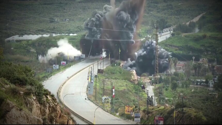
In an investigative investigation, colleague Salam Khader tracked the Israeli military strategy in the southern regions, which included the systematic destruction of infrastructure.
The investigation monitored the issuance of 135 military evacuation orders, which led to the displacement of about 800,000 people from their homes, within a range extending from the course of the Litani River to the Zahrani River, transforming about 10% of the total area of Lebanon into a closed military operations area to which residents are prevented from returning.
Satellite images from the investigation reveal widespread levels of destruction inflicted on dozens of towns, reaching in several cases the complete destruction of entire border villages.
Demographic affairs expert Ali Faour explained that the Israeli plan directly targeted 73 border villages extending from Naqoura in the west to the Khiam area and Wadi Al-Hujair in the east, with the aim of permanently evacuating them from population presence and turning them into a buffer zone.

The digital data and photos complement the testimonies of the people, as Hassan Sarhan narrated the details of his displacement, explaining that the trip, which normally takes an hour and a quarter from the south to Beirut, took him and his family more than 12 hours along mountainous roads, while the journey of others extended about 25 hours as a result of the ongoing military operations.
International law positions
The Israeli field movement did not stop at the borders of the international “Blue Line” approved by the United Nations since 2000, but was embodied on the ground by publishing a map of the so-called “Advanced Defense Line” or “Yellow Line.”
This alternative belt extends between 5 and 10 kilometers deep into Lebanese territory, to include more than 60 towns and farms with a total area exceeding 600 square kilometers, extending from the seashore, all the way to the eastern Lebanon mountain range.

According to the investigation, this geographical change coincided with statements by ministers in the Israeli government, as Israeli Defense Minister Israel Katz issued orders to destroy bridges over the Litani River and demolish homes in border villages.
In light of these facts, experts in international law are searching for legal evidence to convict Israeli officials. International law specialist Diala Shehadeh believes that these documented official statements constitute a basis for proving the intention to commit the crime of forced displacement.
In the same context, international law expert Abdel Majeed Al-Marari pointed out that Israeli practices in the southern villages aim to end the necessities of life in those areas, which is indicated by the reports of the United Nations Human Rights Office, which documented the expansion of the eviction area to include 14% of the country’s territory.