In southern Lebanon, the town of Aitaroun does not appear to be just another dot on the map of the affected border villages. The town, located in the Bint Jbeil district, turned during the year 2026 into one of the areas that summarize the nature of the new confrontation along the Blue Line, including repeated bombings, nearby Israeli military sites, field movements on the hills, and Lebanese concern about turning the front villages into buffer zones that are difficult for residents to return to.
Satellite images analyzed by the Al Jazeera Network’s open source unit showed widespread changes in the appearance of the urban bloc of the town of Aitaroun between February 13 and June 23, 2026.
Read also
list of 3 itemsend of list
Visual comparison reveals severe destruction in large parts of the town, and a clear change in the form of the urban fabric. Whereas the residential areas appeared in the February images with regular blocks and clear urban boundaries, in the June images they appeared more disintegrated, with the boundaries of the damaged buildings overlapping with roads and open spaces.
Images taken between June 18 and 23 also showed continued destruction inside the town during the last week of monitoring, indicating that the changes were not limited to an early stage of escalation, but rather continued until late June.
Hills touching
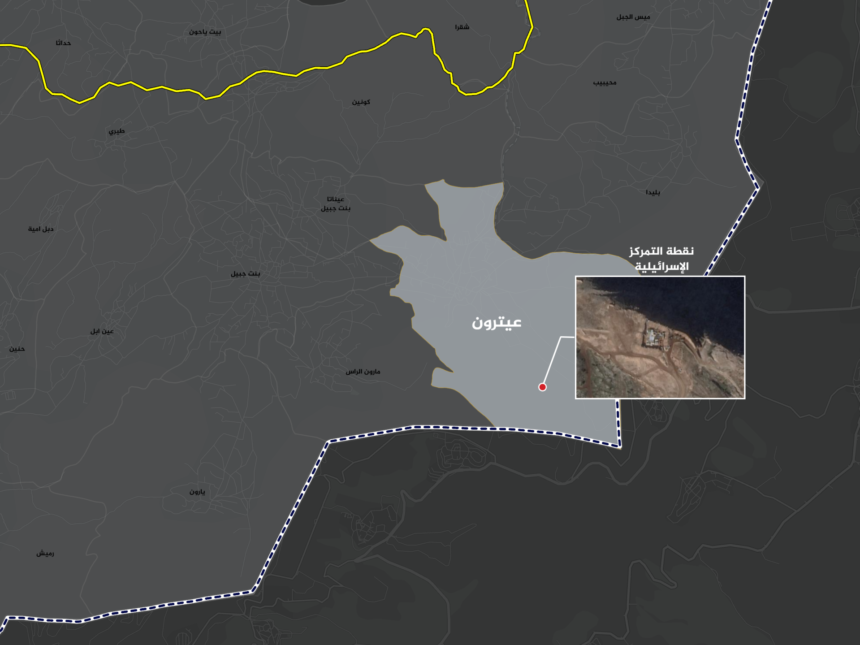
Aitaroun gains its importance from its location near the towns of Maroun al-Ras and Blida, and from its proximity to the Jal al-Deir area south of it, where a map prepared by Al Jazeera based on satellite images shows the location of an Israeli concentration point from which no withdrawal was made.
From the Israeli side, the town faces the settlements of Avivim and Al-Malikiyah, which places it within the range of direct surveillance and fire, and gives the surrounding hills military importance in monitoring and controlling the axes of movement in the central sector of the border.
Aitaroun is located in a very sensitive area on the ground, where the front Lebanese villages overlap with high sites overlooking the Israeli side and internal roads in southern Lebanon, which makes any field change in its surroundings part of a broader equation related to the Blue Line, the Israeli expansion, and the return of the population.

Israeli point
On February 13, 2026, Lebanese reports reported that the vicinity of Aitaroun and Blida came under fire from opposing Israeli positions, including the Al-Malikiyah area. This event reflects continued friction on the border axes, even before the widespread escalation that the south witnessed later.
On February 26, there were reports that the Al-Zaqaq neighborhood in Aitaroun was targeted by mortar shells from Israeli forces stationed in a new location at Jabal Al-Bat.
A year under fire
Earlier, the Al Jazeera Open Sources Unit monitored, via satellite images, 5 Israeli military concentration sites north of the Blue Line inside southern Lebanon, including a site in the Aitaroun area.
On March 3, the United Nations Interim Force in Lebanon (UNIFIL) said that the Israeli army maintained 5 sites and two isolation areas inside Lebanon, and considered this a violation of Resolution 1701.
The UNIFIL statement does not limit the discussion to Aitaroun alone, but rather places the Jal al-Deir location south of the town within a broader context of border points that turned into concentration sites or isolation areas after the escalation.
Internal sites
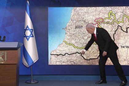
A geographical comparison between two maps published by the Israeli army showed a change in the borders of the area it defines as a security buffer zone in southern Lebanon, about two months after the ceasefire agreement announced on April 17.
The Al Jazeera network’s open source unit analyzed the map published by the Israeli army on June 18, and compared it with the borders of the area that were approved after the ceasefire agreement. It was found that the Israeli-specified area expanded from about 590 square kilometers to about 650 square kilometers.
The results of the spatial comparison indicate an increase of approximately 60 square kilometers, equivalent to about 10% compared to the previous borders, according to measurements conducted by the unit on the two maps.

Digital elevation models analyzed by the unit indicate that the added areas are located on relatively high points compared to the surrounding lands, giving it a greater ability to visually supervise and monitor nearby axes, valleys and towns.
New agreement
Aitaroun’s monitoring comes in light of a new Israeli-Lebanese agreement, sponsored by America, that aims to stabilize the ceasefire and rearrange the security situation in the south, through a greater role for the Lebanese army and linking the Israeli withdrawal and stabilization of calm to Hezbollah’s weapons file south of the Litani.
But Aitaroun reveals the limits of this agreement on the ground. The presence of Israeli sites inside Lebanon, the continued talk about Israeli freedom of action, and the repeated bombings and bombings near the border villages, are all factors that put the agreement under a direct test: Does it actually lead to the withdrawal and return of the population, or does it establish a transitional reality in which the front villages remain between a truce and fire?
What does the occupation army say?
Israel presents its operations in southern Lebanon as defensive measures aimed at protecting the northern settlements and preventing Hezbollah from rebuilding its capabilities near the border.
According to Israeli army statements, ground operations and stabilization of the front line aim to remove direct threats, dismantle military structures, and prevent anti-tank or missile fire from nearby areas.
Israeli sources also spoke of the continued “freedom of action” in Lebanon against any direct or emerging threat. This means, in practical terms, that Israel does not link every field movement to the ceasefire alone, but rather leaves itself a wide margin to carry out strikes, bombings, or engineering operations on the border.
At the Lebanese level, these movements are presented as a violation of sovereignty and an obstacle to the return of residents to their towns. The Lebanese presidency and government stressed the need to stop Israeli attacks.
In this context, Aitaroun summarizes the dilemma of southern Lebanon. It is a civilian border town located in an area of high military value, and its residents are paying the price for its location between a blue line that is no longer calm, hills that have turned into observation and fire points, and an open political and security battle over the meaning of withdrawal, sovereignty, and return.